Sunday, 19 January 2014

Old Coach Road

January 9th. A shuttle bus dropped me&my bike at the Turoa skifield, located at the slopes of Mount Ruapehu.


The road is just 17 km long, but the vertical ascent is 1020 metres! The highest point offered nice views over the surroundings, of which some parts were used in the Lord of the Rings and Hobbit movies.


From the mountain road, some side tracks were available for good walks. This waterfall is famous, as Gollum caught a fish in the pool in one of the Lord of Rings movies.


Another waterfall, further down the mountain.


Back in Ohakune, I proceeded with the Old Coach Road. It has a very interesting history! A long time ago, a railroad was constructed from Auckland to Wellington. In 1906, the railroad was all completed, except for a small section between Ohakune and Horopito. At these two places, the train passengers and goods would be transferred to no less than ten coaches, each pulled by five horses, which moved along the Coach Road, made of cobblestones in the earth, and then loaded into the other train again.

By 1908, the railroad was completed. It could not be too steep, so it curved around a lot. The Coach Road itself was no longer needed. It became forgotten, and forest quickly took it all over.

And later in the century, new trains had much more power allowing to traverse much steeper slopes. So the railroad was straightened, new bridges were built and old bridges got out of service. Also the old railway became forgotten.

Only few people still knew about the existence of the Coach Road. By 2002, they thought it'd be cool to walk/cycle over the road again, and began reconstructing the original road. Combined with parts of the original railway, the Old Coach Road was re-opened, with a number of signs along the way to show parts of the history.

The cobblestones are still there, in the road.


One of the bridges, now accessible for walking and cycling.


Another bridge, fully made of steel; not accessible.

It was fun to travel all way of the Old Coach Road, and back to Ohakune again!

Full gallery here!

Tuesday, 14 January 2014

Climbing Mt Doom

Jan 7th. In the central region of North Island lie the Ruapehu, Ngauruhoe and Tongariro volcanoes. The latter two are close together, and the day walk across the saddle connecting the two is known as the Tongariro Crossing.

Mt Ngauruhoe, also known as Mt Doom

Mt Ngauruhoe made its film debut as Mt Doom in the Lord of the Rings movies. The fields around it are dark and rocky; even though it is summer, very little plants would grow on it. Yes, Morder, no surprise of course.

On top of Mt Tongariro, looking over Mt Ngauruhoe and Mt Ruapehu

Two interesting side trips are possible from the saddle: the one going to the Tongariro summit, and the other to the top of Ngauruhoe, Mt Doom himself. I made for the Tongariro summit as this had the best views over Mt Doom (and was the easier one), and indeed reached it.

A dark yellow, cursed lake. Sulphur? Better not drink it!

Geology also became increasingly more interesting. The rocks have many different colors: besides black, gray and white, I also found red, yellow, blue and even purple stones. And the lakes around here are not only in blue, but also in dark yellow. And one crater rim was almost entirely colored dark red, quite creepy.

White smoke rising from one of the craters

From several places, kind of white smoke was coming out of the earth. Yes, this represented volcanic activity and boiling liquids. There were warning signs everywhere, and my campsite also was in an increased lahar risk zone. If one volcano would erupt, the campsite could be devasated by it. I was not impressed, though, and completed the crossing and stayed two nights at the campsite.

A helpful tour operator looking at my car

Back at the car, I found out that the double-V belt had slipped of again! For the second time in seven days. The next day a mechanic fixed it, and suggested that one pulley's bearing was getting weary and needed to be replaced. But replacement parts for French cars are scarce, and a new pulley bearing would have to be ordered from France, taking three weeks! Panic, crisis? Not for me, I'd rather call it a challenge.

I knew I was taking risks when I bought my car, and was determined to finish the journey with it anyhow. So I drove to an engineering shop in Ohakune and bought the tools necessary to mount the belt myself. I also needed a bolt with certain dimensions that the shop didn't have, but they were kind enough to wield one bolt specifically for me. Now I could put the belt back and adjust its tension, if necessary. Hoppa, keep on rollin'!

Photo gallery here!

Sheep shearing

After some adventures with the car (the double-V belt slipped off) and taking the ferry to Wellington in the midst of the night, I finally arrived in Taihape on Jan 5th.

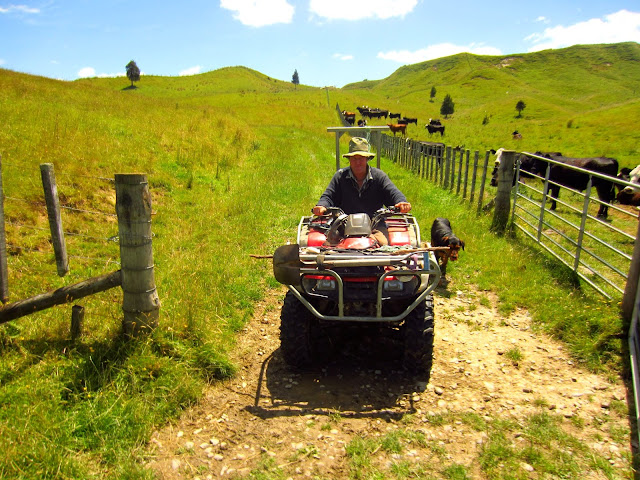
Chris welcomed me at his "little" sheep farm. 1200 sheep he has, on a piece of land 4 km in diameter. And this is called "little"?!


Chris riding on the quad, flanked by one of his dogs.


My friend Karolin planted these threes a few years ago. They are growing well, Chris said. He built a fence around the trees and expects they will become beautiful big trees in 20 years.


We like to have clean wool, but sheep can be dirty at times, with poop sticking to the wool. So we were going to "clean" them, i.e. shave the mess off their butts. First we whipped a flock into a shed, from which smaller groups were led to a smaller room and finally to the torture room one by one.


Sheep are ever unmanageable creatures, except when they are lying on their back with all legs sticking into the air! So the first step is to turn the beasts upside down. A lamb can be handled quite easily with one hand, but the bigger monsters need some pressure to get them in the right position. First you had to grab the head with your left hand and bend it 180 degrees to the right, then push your right knee to their back and at the same time pull the body downwards and towards you; if necessary kicking their back legs out; next you had to grab his long breast hair and pull 'em upwards, idling the upper legs as well and now even the fiercest orc becomes tame as lamb!


Here you see Chris doing the actual job. I also mimicked shaving one sheep for the picture (see gallery). I am a sheep farmer now, says Chris. Awesome!


We also visited one of the sheep wool shearing barns. This one is next to his house; the sheep are actually his neighbour's, but a sheep is a sheep, right?!


In the afternoon we visited Mike and Adele's place, who had built a group of beautiful little houses and sheds all by themselves. They also grow a number of vegetables.


Mike lets the bees (and the worms) work for him. Good craftmanship, I'd say!

Thanks Chris for the very interesting experience out there!

Photo gallery

Monday, 13 January 2014

Abel Tasman

Marahau, December 28. The angel Marjon saved all my problems by handing me a thick envelope, filled with enough $$$ for the rest of my journey. Gabriel, Cyrielle, Arthur and Martha joined the party too. Gabriel and I shuffled one car to the endpoint, and so started the Great Walk a few hours later than the others. Later, Maciek and Laura also joined the party, bringing the total to eight people, of which I had only seen Marjon just once before. But great walks also makes great friends...

Preparing for departure at some campsite

Martha, Cyrielle, Marjon, Arthur, Gabriel, Vincent, Laura, Maciek

The following four days all went quite similar: Get up, swim in the sea (if sunny), breakfast, pack soaked tents, go out walking through forest in rain/sun, make tea/lunch, walk along golden beaches and under palm trees, set up tents, go snorkling (if sunny), make campfire, prepare dinner, count stars in the night sky, tell stories, listen music, go sleep.

Finally, an afternoon full of sun!
One of the campfires we had under the stars
Time to dive into the sea and chase some fish! (yeah, that's me)

Only the last night (Dec 31th) was a little bit different. We had strategically placed Martha's car halfway the last two campsites, and it was filled with wine and tasty food. So we had a good drink at New Year's Eve, and celebrated the first seconds of 2014 at the beach. A few moments later, one rushed into the sea for the traditional New Year's Dive, and many of us (including me) followed! It was cooooooold, but felt awesome and we quickly warmed up again around the massively big fire.

Taking off our clothes before jumping in the sea, in the first minutes of 2014! (30 sec exposure)

I'd say it was an unforgettable way of experiencing New Year. Walking for five days through rain and sun, carrying all the food and stuff in our backpacks, sleeping next to the most golden beaches I have ever seen, turning strangers into friends, swum among beautifully-colored fishes in the (sometimes) crystal clear sea, and simply feeling the air of Nature's freedom, far away from the cities.

Photo album here!

Sunday, 12 January 2014

Queen Charlotte Track

Christmas. How to celebrate it without family, far away from home?


Simple: with a Kiwi-style Christmas "BBQ" dinner together with other "orphan" friends! Photo by Tania, and it should be noted that Zeinab jumped in 5 minutes after taking this picture.


The day after, I drove north, all way north to the Picton harbour. The plan was to take the water-taxi to Punga Cove, my starting point of the Queen Charlotte trail. But when I tried to get cash (needed for the taxi), my bank card suddenly rejected any transaction!

It turned out that my bank had blocked my card, and that a new one was sent to my home in The Netherlands. Ummm, let's check... $70 in my pocket, and taxi costs $115 not to mention the other costs for my journey. Oh wait, I've got €200 cash somewhere, yes! Need to change it to NZ$$$. But: the bank is closed. Boxing Day. It should actually be called (Christmas Present) Unboxing day, but well, the taxi office is kind enough to postpone payment to the next day.


It's 41 km from start to finish (the remaining 26 km can't be cycled during summer). I chose to cover it in two days, a wise choice because it's mostly an advanced (grade 4) track with rough paths and very steep slopes. Initially it was a walking track only, and at some sections walking is indeed easier than cycling. The track was also rather muddy, because of the rain in the past days.


The trail is on a peninsula, a long and narrow piece of land with many bays at both sides. Most of the time the path flows over the ridge, with beautiful views in all directions.


It was generally cloudy, but it didn't rain again and at times the sun broke through.


One of the many 'summits', which were never higher than approx. 400m. The trail felt like a chain of hills, connected by saddles between them.


Halfway, I picked up my backpack (which the boat had dropped for me) and set up my tent for a good rest.


Next morning, the second part started, again flowing through the forest following the ridge connecting the hill tops. The track also gradually got easier, and there were some very nice downhill sections at the end.


Finally I arrived at the beach in Anakiwa, soon to be picked up by the fastest water taxi of the region, arriving in Picton only 10 minutes before the local bank would close. Luckily, Picton is just a little harbour village, and I cycled the distance from harbour to bank in under 60 seconds. With fresh NZ dollars, I paid the taxi and saved about just enough for a large pizza (for me), petrol (for my car) and one night's stay for the journey to Marahau where my next adventure would start.

Sunday, 5 January 2014

Angelus Hut

Friday December 13th. I picked up Milos and Patrick, then drove to Nelson Lakes, about five hours from Christchurch. We camped on the shore of Lake Rotoiti. It was already dark when we set up tents, and after enjoying a quick meal we set up our cameras for some nice night photographs.


It was difficult to find a good place where you could see the reflection of the stars in the lake, but here I found one! Can you spot the (two) Southern Cross constellations?


Twenty seconds of wave ripples blurred the reflections out. The image above is actually a composition of two shots, to get a better balance of the scene brightness.


Next morning we drove to the start of the Robert Ridge route, at an elevation of 880m, and started our actual tramp. The first part is a very steep ascent, climbing to about 1400m. From there on, the route goes over a long ridge, bridging several mountain tops up to 1800m.


The nice thing about walking over a ridge is that you always have spectacular views in all directions! But it is also quite exposed, so it can be very, very cold and windy up there. Luckily we had about perfect weather, walking alternatingly in sun and shade (from the clouds).


Pretty easy to find the way. Just keep walking as high as you could get, and occasionally looking for orange track markers.


Finally we arrived at Lake Angelus (1650m), with the beautiful hut on its bank.


After a quick meal we decided to walk a little further, to Sunset Saddle. Patrick was hearing strange sounds and looked if someone might need help; Milos attempted to climb Angelus Peak itself but got stuck on a steep slope, and I myself managed to climb Sunset Saddle giving another beautiful view around.


In the night Milos and I went out again for some advanced night photography, mainly involving waterfalls and stars.


Next morning we took the Speargrass Track route back, which follows the Speargrass Creek almost all the way. It's the opposite of the Robert Ridge route in many aspects: well covered, little scenic views, lots of water and vegetation.


Sunday night we finally got home. Tired. Sleep. But again with loads of cool photos from the trip!


Friday, 3 January 2014

Sinterklaas and Cass-Lagoon

Sinterklaas! Time to learn the Kiwis one of the most famous Dutch traditions of December 5th. Ok, with some minor modifications: because of the awesome weather we started with a tennis tournament followed by a BBQ!


After the BBQ we played a dice game. Depending on certain rolls one could grab (or unwrap) a present from the large bag. Later, cards came into play as well, mostly shuffling presents according to dumb criteria which usually turned out our black pete Sandeep collecting most of them as he was also the only one wearing a moustache, beard and glasses, and apparently also being the biggest know-it-all of the house. Luckily there were many other types of command cards too, so in the end nobody got home empty-handed. Unfortunately no pictures by me of the Sinterklaas party or BBQ; Sandeep made a few and I hope to add them here later.


The Sinterklaas party ended very late on Friday, but we didn't get much rest as we planned to set off to Cass-Lagoon on Saturday by 8am. Well, at 8:30am everyone was present except Niko. He couldn't be reached by phone, so we drove to his flat and broke in through a window, finding him fast asleep in his room. I threw a cup of cold water over him, and this resurrected him quite well! A few minutes later, the nine of us finally set off to Cass-Lagoon, a 31 km walk crossing two main saddles and following rivers flowing through the valleys.


Rain. Yes, we learned: it rains when it rains and it keeps raining as long as it likes to do so. Trip leader Tania had wisely decided to start at the Lagoon side of the track, so that we didn't have to cross any rivers before reaching the first shelter, near the top of the Lagoon saddle.


We had walked in good mood, but it became clear that the group pace was too slow to reach the next hut in time. So we decided to split up in two groups: the cracks going further, and the chicks staying at Lagoon saddle.


Dave, Niko, Milos and I headed on...


...and finally we reached Hamilton Hut. We had a good dinner, and discussed plans for the night. I was keen for some long exposure photographing close to the hut, and Niko would go off to a valley near West Harper Hut and climb one of the peaks west from there. Yes, on his own on a rainy night. You just have to know him to understand him.

I walked from the hut to the stream at the other side of the valley. The low crescent moon was barely visible behind the clouds. Candles illuminated the hut from inside, giving a good guide for the way back. Apart from that, it was just plain darkness. I made a few nice shots, using my headlamp to illuminate the river and landscape and started my way back to the hut when rain was increasing again. The hut... where was it?

All the hut's candles were out, and I stared into the darkness. Oops. There you go: navigation at night without map, compass or GPS. Relax. Stay calm. Head into the approximate direction. Can't get further, was it right or left? An orange triangle, a track marker. Tried left. Wrong, of course: we had reached the hut through the woods, and not by the river, but my mind was running a bit slow. After 5 minutes I finally learned I'd better turn 180 degrees. Yes, found the pathway up to the hut! And I also saw Niko, shivering in front of the hut.


"Did you climb that peak?", I asked. "No", Niko replied, and he pointed to his Black Diamond headlamp on the ground. Dead. We lighted the fireplace and Niko told his story. Far away from the hut, his headlamp had suddenly stopped working!

An average tramper would be well-equipped with spare items and emergency stuff, especially when going out at night in poor weather. But not Niko, who had just his boots, shorts and shirt on. Not that he really needed spare or emergency stuff. Remembering the path he had taken, he managed to travel all way back to Hamilton Hut. River crossings in total darkness. Crouching on hands and feet to sense the stones and hills, listening to the streams that guided the overall direction. Many kilometres, about all way from West Harper Hut to Hamilton Hut. The longer I think about it, the more impossible I consider this achievement. Yes, it's always Niko... the craziest but also the toughest tramper of our club, I think!


Next morning we first visited Mirror Tarn. Under good conditions it would be a nice spot for landscape photography, but this time the 'mirror' was broken by the ever-ongoing rain.


We then set off to the Cass saddle, climbing the hills through bush from where strange voices could be heard.


In the afternoon we arrived at Cass saddle. The photo above is taken by Milos, using a special camera filter to maintain good overall exposure balance (and a self-timer of course).

We then descended from the saddle along the Cass river. This started as a little stream (just a few centimeters deep and wide), and grew bigger and wilder as more side-streams flowed into it. At many places we had to cross the river, which was getting increasingly harder and eventually needed mutual support.


Finally, we reached the main road, soaked and with sore legs. This was the end for another nice tramp. It was quite wet, but still pleasing. And those nightly adventures... something you can keep on talking about for a long time!

Full album here!